
Obrigado por apoiar este site ❤️
Faça uma doação
Faça uma doação
Prepare-se para a sua próxima aventura:
Como Associado da Amazon, este site recebe uma comissão sobre compras elegíveis sem custo adicional para si.
Mapa topográfico Rockley
Clique no mapa para exibir a altitude.
Obrigado por apoiar este site ❤️
Faça uma doação
Faça uma doação
Prepare-se para a sua próxima aventura:
Como Associado da Amazon, este site recebe uma comissão sobre compras elegíveis sem custo adicional para si.
Sobre este mapa
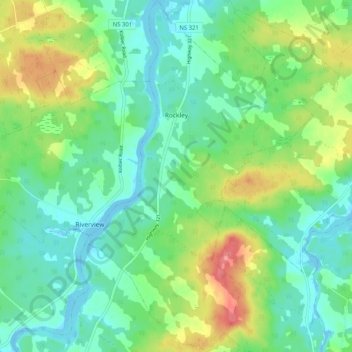
Nome: Mapa topográfico Rockley, altitude, relevo.
Altitude média: 24 m
Altitude mínima: -4 m
Altitude máxima: 74 m
Obrigado por apoiar este site ❤️
Faça uma doação
Faça uma doação
Prepare-se para a sua próxima aventura:
📟Walkie-Talkies de Longo Alcance - Sistemas de comunicação rádio para equipas em zonas sem cobertura móvel
Como Associado da Amazon, este site recebe uma comissão sobre compras elegíveis sem custo adicional para si.
Outros mapas topográficos
Clique em um mapa para visualizar sua topografia, sua altitude e seu relevo.
Wentworth Provincial Park
Canada > Nova Scotia > Municipality of the County of Cumberland > Wentworth Station
Altitude média: 81 m