
Mapa topográfico Schwanden
Mapa interativo
Clique no mapa para exibir a altitude.
Sobre este mapa
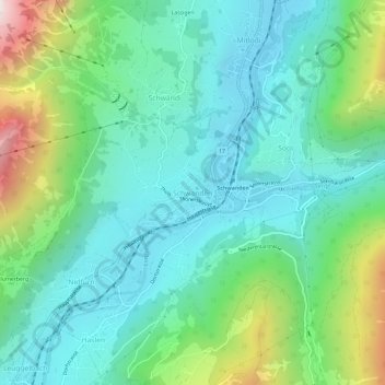
Nome: Mapa topográfico Schwanden, altitude, relevo.
Local: Schwanden, Glarus Süd, Glarus, 8762, Switzerland (46.97556 9.05136 47.01556 9.09136)
Altitude média: 813 m
Altitude mínima: 498 m
Altitude máxima: 1744 m
Schwanden is situated at an elevation of 528 m (1,732 ft) at the point of confluence of the Linth and Sernf rivers. The village is located along the roads to Elm, Linthal and Schwändi, and includes the formerly independent (until 1876) hamlet of Thon. The villages of Nidfurn and Haslen lie to south in the valley of the Linth, whilst the village of Engi lies to the east in the valley of the Sernf. To the north, the village of Mitlödi lies in the valley of the Linth, whilst Schwandi and Sool are respectively on the west and east slopes of the valley.
Outros mapas topográficos
Clique em um mapa para visualizar sua topografia, sua altitude e seu relevo.
Braunwald
Switzerland > Glarus > Glarus Süd
Braunwald, Glarus Süd, Glarus, 8784, Switzerland
Altitude média: 1215 m
Schwander Grat
Switzerland > Glarus > Glarus Süd
Schwander Grat, Glarus Süd, Glarus, 8774, Switzerland
Altitude média: 2289 m
Mitlödi
Switzerland > Glarus > Glarus Süd > Mitlödi
Mitlödi, Glarus Süd, Glarus, 8756, Switzerland
Altitude média: 800 m