
Mapa topográfico Braunwald
Mapa interativo
Clique no mapa para exibir a altitude.
Sobre este mapa
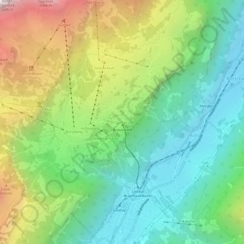
Nome: Mapa topográfico Braunwald, altitude, relevo.
Local: Braunwald, Glarus Süd, Glarus, 8784, Switzerland (46.91926 8.97850 46.95926 9.01850)
Altitude média: 1215 m
Altitude mínima: 588 m
Altitude máxima: 2399 m
Braunwald is situated in the Glarus Alps on a terrace above the Linth valley, at an elevation of 1,256 meters (4,121 ft). It overlooks the villages of Linthal and Rüti in the valley below. It is overlooked by the mountains of Ortstock (2,717 m or 8,914 ft), Höch Turm (2,666 m or 8,747 ft), Eggstock (2,455 m or 8,054 ft) and Bös Fulen (2,802 m or 9,193 ft).
Outros mapas topográficos
Clique em um mapa para visualizar sua topografia, sua altitude e seu relevo.
Schwanden
Switzerland > Glarus > Glarus Süd
Schwanden, Glarus Süd, Glarus, 8762, Switzerland
Altitude média: 813 m
Schwander Grat
Switzerland > Glarus > Glarus Süd
Schwander Grat, Glarus Süd, Glarus, 8774, Switzerland
Altitude média: 2289 m
Mitlödi
Switzerland > Glarus > Glarus Süd > Mitlödi
Mitlödi, Glarus Süd, Glarus, 8756, Switzerland
Altitude média: 800 m