
Mapa topográfico Ocean County
Mapa interativo
Clique no mapa para exibir a altitude.
Sobre este mapa
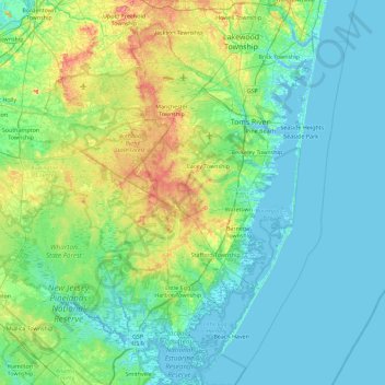
Nome: Mapa topográfico Ocean County, altitude, relevo.
Local: Ocean County, New Jersey, United States of America (39.47520 -74.55311 40.17236 -73.96611)
Altitude média: 15 m
Altitude mínima: -2 m
Altitude máxima: 78 m
Much of the county is flat and coastal, with many beaches. The highest point is one of three unnamed hills (one in Jackson Township, the other two in Plumsted Township) that reach at least 230 feet (70 m) in elevation. The lowest elevation in the county is sea level.
Outros mapas topográficos
Clique em um mapa para visualizar sua topografia, sua altitude e seu relevo.
Passaic County
United States of America > New Jersey
Passaic County, New Jersey, United States of America
Altitude média: 182 m
Atlantic County
United States of America > New Jersey
Atlantic County, New Jersey, United States of America
Altitude média: 15 m