
Mapa topográfico Atlantic County
Mapa interativo
Clique no mapa para exibir a altitude.
Sobre este mapa
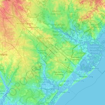
Nome: Mapa topográfico Atlantic County, altitude, relevo.
Local: Atlantic County, New Jersey, United States of America (39.26205 -74.98522 39.72991 -74.23182)
Altitude média: 15 m
Altitude mínima: -4 m
Altitude máxima: 64 m
The county lies along the Atlantic Coastal Plain, with sea level and the Atlantic Ocean to the east. Adjacent to the coast are three barrier islands – Absecon Island (Which contains Atlantic City, Ventnor, Margate, and Longport), Brigantine Island, and Little Beach. To the west of the barrier islands, 4 mi (6 km) stretch of marshlands, inlets, and waterways connect and form the Intracoastal Waterway. Beneath the county is a mile of clay and sand that contains the Kirkwood–Cohansey aquifer, which supplies fresh groundwater for all of the streams and rivers in the region. The interior of the county is part of the Pine Barrens, which covers the southern third of New Jersey, and is prone to forest fires. Lowland areas are swampy and contain pitch pine or white cedar trees. Upland areas in the west of the county are hilly, containing oak and pine trees. The highest elevation in the county – about 150 ft (46 m) above sea level – is found near the border with Camden County, just west of Hammonton. The county's western boundary with Burlington and Camden counties, clarified in 1761, is a manmade line about halfway between the Atlantic Ocean and the Delaware Bay.
Outros mapas topográficos
Clique em um mapa para visualizar sua topografia, sua altitude e seu relevo.
Passaic County
United States of America > New Jersey
Passaic County, New Jersey, United States of America
Altitude média: 182 m
Ocean County
United States of America > New Jersey
Ocean County, New Jersey, United States of America
Altitude média: 15 m