
Mapa topográfico Eastern Ghats
Mapa interativo
Clique no mapa para exibir a altitude.
Sobre este mapa
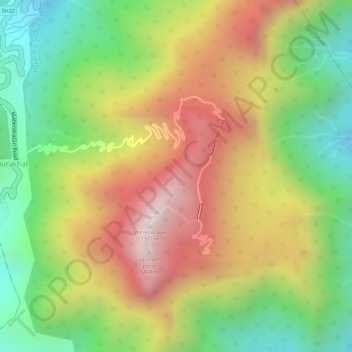
Nome: Mapa topográfico Eastern Ghats, altitude, relevo.
Altitude média: 1130 m
Altitude mínima: 777 m
Altitude máxima: 1494 m
The Maliya Range is located in the northern portion of the Eastern Ghats, generally ranging between elevations of 900–1,200 m. The tallest peak in this range is Mahendragiri (1,501 m).
Outros mapas topográficos
Clique em um mapa para visualizar sua topografia, sua altitude e seu relevo.
Mahendragiri
India > Odisha > Ramagiri > Burakhat
Mahendragiri, Burakhat, Ramagiri, Gajapati District, Odisha, India
Altitude média: 1108 m