
Mapa topográfico Lyndhurst
Mapa interativo
Clique no mapa para exibir a altitude.
Sobre este mapa
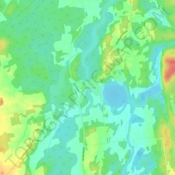
Nome: Mapa topográfico Lyndhurst, altitude, relevo.
Altitude média: 98 m
Altitude mínima: 81 m
Altitude máxima: 130 m
Outros mapas topográficos
Clique em um mapa para visualizar sua topografia, sua altitude e seu relevo.
Lansdowne
Canada > Ontario > Leeds and Grenville Counties > Leeds and the Thousand Islands
Lansdowne, Leeds and the Thousand Islands, Leeds and Grenville Counties, Eastern Ontario, Ontario, K0E 1L0, Canada
Altitude média: 101 m
Seeleys Bay
Canada > Ontario > Leeds and Grenville Counties > Leeds and the Thousand Islands > Seeley's Bay
Seeleys Bay, Seeley's Bay, Leeds and the Thousand Islands, Leeds and Grenville Counties, Eastern Ontario, Ontario, K0H 2N0, Canada
Altitude média: 105 m
Leeds
Canada > Ontario > Leeds and Grenville Counties > Leeds and the Thousand Islands
Leeds, Leeds and the Thousand Islands, Leeds and Grenville Counties, Eastern Ontario, Ontario, Canada
Altitude média: 104 m
Seeley's Bay
Canada > Ontario > Leeds and Grenville Counties > Leeds and the Thousand Islands > Seeley's Bay
Seeley's Bay, Leeds and the Thousand Islands, Leeds and Grenville Counties, Eastern Ontario, Ontario, K0H 2N0, Canada
Altitude média: 106 m
Blue Mountain
Canada > Ontario > Leeds and Grenville Counties > Leeds and the Thousand Islands
Blue Mountain, Leeds and the Thousand Islands, Leeds and Grenville Counties, Eastern Ontario, Ontario, Canada
Altitude média: 124 m
Waterton
Canada > Ontario > Leeds and Grenville Counties > Leeds and the Thousand Islands > Waterton
Waterton, Leeds and the Thousand Islands, Leeds and Grenville Counties, Eastern Ontario, Ontario, Canada
Altitude média: 97 m