
Faça uma doação
Prepare-se para a sua próxima aventura:
Como Associado da Amazon, este site recebe uma comissão sobre compras elegíveis sem custo adicional para si.
Mapa topográfico Lansdowne
Clique no mapa para exibir a altitude.
Faça uma doação
Prepare-se para a sua próxima aventura:
Como Associado da Amazon, este site recebe uma comissão sobre compras elegíveis sem custo adicional para si.
Sobre este mapa
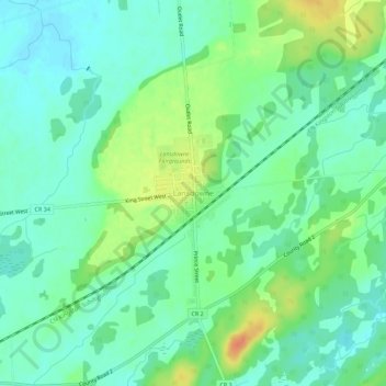
Nome: Mapa topográfico Lansdowne, altitude, relevo.
Altitude média: 101 m
Altitude mínima: 87 m
Altitude máxima: 128 m
Faça uma doação
Prepare-se para a sua próxima aventura:
Como Associado da Amazon, este site recebe uma comissão sobre compras elegíveis sem custo adicional para si.
Outros mapas topográficos
Clique em um mapa para visualizar sua topografia, sua altitude e seu relevo.
Charleston Lake
Canada > Ontario > Leeds and Grenville Counties > Leeds and the Thousand Islands > Outlet
Altitude média: 103 m
Thousand Islands National Park
Canada > Ontario > Leeds and Grenville Counties > Leeds and the Thousand Islands > Rockport
Altitude média: 116 m
Gananoque Lake
Canada > Ontario > Leeds and Grenville Counties > Leeds and the Thousand Islands
Altitude média: 92 m
Leeds
Canada > Ontario > Leeds and Grenville Counties > Leeds and the Thousand Islands
Altitude média: 104 m
Faça uma doação
Prepare-se para a sua próxima aventura:
Como Associado da Amazon, este site recebe uma comissão sobre compras elegíveis sem custo adicional para si.
Leeds
Canada > Ontario > Leeds and Grenville Counties > Leeds and the Thousand Islands
Altitude média: 104 m
Codfish Island
Canada > Ontario > Leeds and Grenville Counties > Leeds and the Thousand Islands
Altitude média: 79 m
Why Island
Canada > Ontario > Leeds and Grenville Counties > Leeds and the Thousand Islands
Altitude média: 92 m