
Mapa topográfico Hirta
Clique no mapa para exibir a altitude.
Sobre este mapa
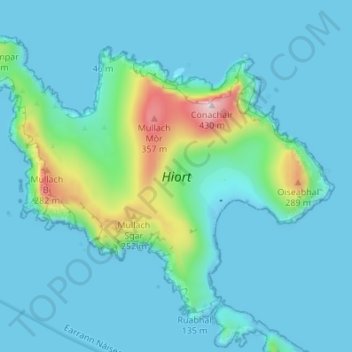
Nome: Mapa topográfico Hirta, altitude, relevo.
Local: Hirta, Western Isles, Scotland, United Kingdom (57.79876 -8.61772 57.82838 -8.54960)
Altitude média: 58 m
Altitude mínima: -5 m
Altitude máxima: 425 m
Outros mapas topográficos
Clique em um mapa para visualizar sua topografia, sua altitude e seu relevo.
North Rona
United Kingdom > Scotland > Western Isles
Rona (Scottish Gaelic: Rònaigh) is an uninhabited Scottish island in the North Atlantic. It is often referred to as North Rona to distinguish it from the island of South Rona in the Inner Hebrides. It has an area of 109 hectares (270 acres) and a maximum elevation of 108 metres (354 ft).
Altitude média: 4 m