
Mapa topográfico Homedale
Mapa interativo
Clique no mapa para exibir a altitude.
Sobre este mapa
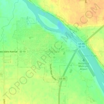
Nome: Mapa topográfico Homedale, altitude, relevo.
Local: Homedale, Owyhee County, Idaho, 83628, United States (43.60864 -116.95120 43.62644 -116.92054)
Altitude média: 683 m
Altitude mínima: 666 m
Altitude máxima: 697 m
Homedale is located at 43°37′8″N 116°56′13″W / 43.61889°N 116.93694°W / 43.61889; -116.93694 (43.618980, −116.936836), at an elevation of 2,231 feet (680 m) above sea level. The city is on the Snake River, which is the border with Canyon County.
Outros mapas topográficos
Clique em um mapa para visualizar sua topografia, sua altitude e seu relevo.
Marsing
United States > Idaho > Owyhee County
Marsing, Owyhee County, Idaho, United States
Altitude média: 694 m
Sinker Butte
United States > Idaho > Owyhee County
Sinker Butte, Owyhee County, Idaho, United States
Altitude média: 892 m
Grand View
United States > Idaho > Owyhee County
Grand View, Owyhee County, Idaho, United States
Altitude média: 737 m
Miller Water Table
United States > Idaho > Owyhee County
Miller Water Table, Owyhee County, Idaho, United States
Altitude média: 1140 m