
Mapa topográfico Nationaal Park De Groote Peel
Mapa interativo
Clique no mapa para exibir a altitude.
Sobre este mapa
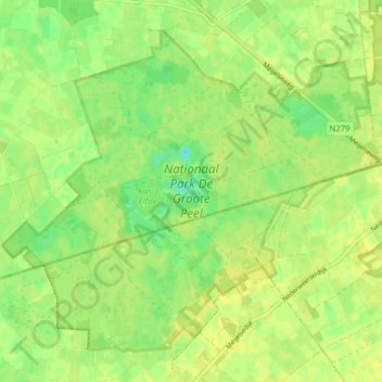
Nome: Mapa topográfico Nationaal Park De Groote Peel, altitude, relevo.
Altitude média: 29 m
Altitude mínima: 18 m
Altitude máxima: 33 m
Outros mapas topográficos
Clique em um mapa para visualizar sua topografia, sua altitude e seu relevo.
Schoor
Nederland > Limburg > Nederweert > Schoor
Schoor, Nederweert, Limburg, Nederland, 6031, Nederland
Altitude média: 33 m