
Mapa topográfico Laval
Mapa interativo
Clique no mapa para exibir a altitude.
Sobre este mapa
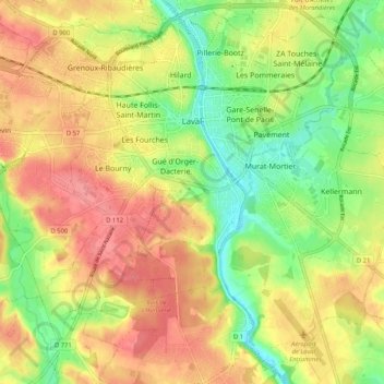
Nome: Mapa topográfico Laval, altitude, relevo.
Altitude média: 87 m
Altitude mínima: 42 m
Altitude máxima: 128 m
Elevation varies between 42 and 122 meters above sea level. Laval is, in fact, a hilly town, marked by a rocky promontory dominating the valley of the Mayenne river. The castle was built on this promontory and the medieval centre spreads around. The promontory and the slightly hilly landscape around Laval are traces of the Armorican Massif, an old range of mountains that forms the Breton peninsula.
Outros mapas topográficos
Clique em um mapa para visualizar sua topografia, sua altitude e seu relevo.
Ballots
France > Pays de la Loire > Mayenne
Ballots, Château-Gontier, Mayenne, Pays de la Loire, Metropolitan France, 53350, France
Altitude média: 71 m