
Mapa topográfico Mytilene Municipal Unit
Mapa interativo
Clique no mapa para exibir a altitude.
Sobre este mapa
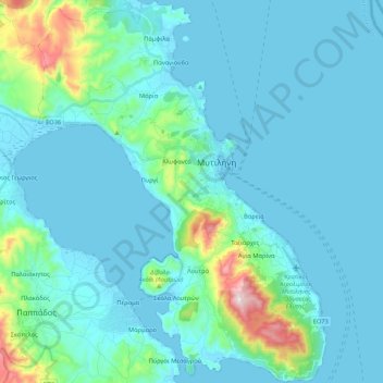
Nome: Mapa topográfico Mytilene Municipal Unit, altitude, relevo.
Altitude média: 67 m
Altitude mínima: -1 m
Altitude máxima: 548 m
Outros mapas topográficos
Clique em um mapa para visualizar sua topografia, sua altitude e seu relevo.
Taxiarches
Greece > Aegean > Lesbos Regional Unit > Mytilene Municipal Unit
Taxiarches, Mytilene Municipal Unit, Municipality of Mytilene, Lesbos Regional Unit, Northern Aegean, Aegean, 811 00, Greece
Altitude média: 149 m
Sigri
Greece > Aegean > Lesbos Regional Unit
Sigri, Municipality of Western Lesvos, Lesbos Regional Unit, Northern Aegean, Aegean, 811 12, Greece
Altitude média: 44 m
Vareia
Greece > Aegean > Lesbos Regional Unit > Mytilene Municipal Unit
Vareia, Mytilene Municipal Unit, Municipality of Mytilene, Lesbos Regional Unit, Northern Aegean, Aegean, 811 00, Greece
Altitude média: 66 m
Mytilene
Greece > Aegean > Lesbos Regional Unit
Mytilene, Mytilene Municipal Unit, Municipality of Mytilene, Lesbos Regional Unit, Northern Aegean, Aegean, 811 00, Greece
Altitude média: 80 m
Λέσβος
Greece > Aegean > Lesbos Regional Unit
Λέσβος, Municipality of Western Lesvos, Lesbos Regional Unit, Northern Aegean, Aegean, Greece
Altitude média: 74 m