
Faça uma doação
Prepare-se para a sua próxima aventura:
Como Associado da Amazon, este site recebe uma comissão sobre compras elegíveis sem custo adicional para si.
Mapa topográfico Walhachin
Clique no mapa para exibir a altitude.
Faça uma doação
Prepare-se para a sua próxima aventura:
Como Associado da Amazon, este site recebe uma comissão sobre compras elegíveis sem custo adicional para si.
Walhachin
In December 1914, the westward advance of the CNoR rail head from Kamloops reached Walhachin. The track follows the valley floor at a much lower elevation than the hamlet proper.
Faça uma doação
Prepare-se para a sua próxima aventura:
Como Associado da Amazon, este site recebe uma comissão sobre compras elegíveis sem custo adicional para si.
Sobre este mapa
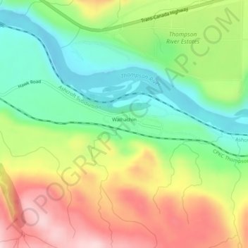
Nome: Mapa topográfico Walhachin, altitude, relevo.
Altitude média: 438 m
Altitude mínima: 315 m
Altitude máxima: 601 m
Faça uma doação
Prepare-se para a sua próxima aventura:
Como Associado da Amazon, este site recebe uma comissão sobre compras elegíveis sem custo adicional para si.
Outros mapas topográficos
Clique em um mapa para visualizar sua topografia, sua altitude e seu relevo.
Spences Bridge
Canada > British Columbia > Thompson-Nicola Regional District > Area I (Blue Sky Country)
Spences Bridge's location is mountainous, with higher elevations part of the Interior Plateau. The east side of the Fraser here is part of the Clear Range, a mountainous southwards extension of the Fraser Plateau located in the angle of the Thompson and Fraser Rivers. Arthur Seat lies in that range on the west…
Altitude média: 496 m
Shaw Springs
Canada > British Columbia > Thompson-Nicola Regional District > Area I (Blue Sky Country)
Altitude média: 472 m
Arthur Seat
Canada > British Columbia > Thompson-Nicola Regional District > Area I (Blue Sky Country)
Altitude média: 1327 m
Spences Bridge
Canada > British Columbia > Thompson-Nicola Regional District > Area I (Blue Sky Country)
Spences Bridge's location is mountainous, with higher elevations part of the Interior Plateau. The east side of the Fraser here is part of the Clear Range, a mountainous southwards extension of the Fraser Plateau located in the angle of the Thompson and Fraser Rivers. Arthur Seat lies in that range on the west…
Altitude média: 496 m
Faça uma doação
Prepare-se para a sua próxima aventura:
Como Associado da Amazon, este site recebe uma comissão sobre compras elegíveis sem custo adicional para si.
Arthur Seat
Canada > British Columbia > Thompson-Nicola Regional District > Area I (Blue Sky Country)
Altitude média: 1327 m