
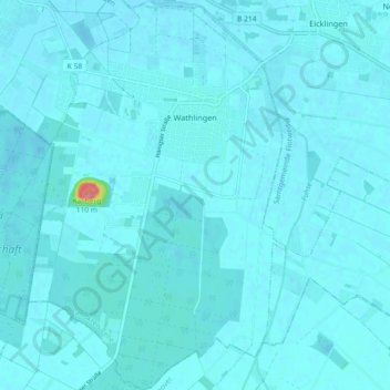
Mapa topográfico Wathlingen
Mapa interativo
Clique no mapa para exibir a altitude.
Sobre este mapa
Nome: Mapa topográfico Wathlingen, altitude, relevo.
Altitude média: 44 m
Altitude mínima: 39 m
Altitude máxima: 131 m
Outros mapas topográficos
Clique em um mapa para visualizar sua topografia, sua altitude e seu relevo.
Celle
Germany > Lower Saxony > Landkreis Celle
Celle, Landkreis Celle, Lower Saxony, Germany
Altitude média: 48 m
Lohheide
Germany > Lower Saxony > Landkreis Celle > Lohheide
Lohheide, Landkreis Celle, Lower Saxony, Germany
Altitude média: 71 m
Faßberg
Germany > Lower Saxony > Landkreis Celle
Faßberg, Landkreis Celle, Lower Saxony, 29328, Germany
Altitude média: 77 m
Klein Hehlen
Germany > Lower Saxony > Landkreis Celle > Celle
Klein Hehlen, Celle, Landkreis Celle, Lower Saxony, Germany
Altitude média: 42 m