
Mapa topográfico Roosevelt Island
Mapa interativo
Clique no mapa para exibir a altitude.
Sobre este mapa
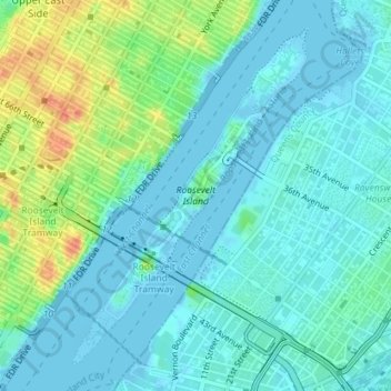
Nome: Mapa topográfico Roosevelt Island, altitude, relevo.
Altitude média: 13 m
Altitude mínima: -6 m
Altitude máxima: 52 m
Outros mapas topográficos
Clique em um mapa para visualizar sua topografia, sua altitude e seu relevo.
Central Park
United States > New York > New York County > New York
Central Park, New York County, New York, United States
Altitude média: 26 m
Manhattan
United States > New York > New York County > New York
Manhattan, New York County, New York, United States
Altitude média: 16 m
Governors Island
United States > New York > New York County > New York
Governors Island, Manhattan, New York County, New York, United States
Altitude média: 1 m
Battery Park
United States > New York > New York County > New York
Battery Park, Financial District, Manhattan, New York County, New York, 10004, United States
Altitude média: 3 m
Highbridge Park
United States > New York > New York County > New York
Highbridge Park, Manhattan, New York County, New York, United States
Altitude média: 30 m
Manhattan Community Board 3
United States > New York > New York County > New York
Manhattan Community Board 3, Manhattan, New York County, New York, United States, Seward Park
Altitude média: 10 m
Hunter’s Point South Waterfront Park
United States > New York > New York County > New York
Hunter’s Point South Waterfront Park, Manhattan Community Board 6, Manhattan, New York County, New York, United States
Altitude média: 5 m