
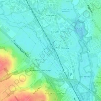
Mapa topográfico Hinksey Stream
Mapa interativo
Clique no mapa para exibir a altitude.
Sobre este mapa
Nome: Mapa topográfico Hinksey Stream, altitude, relevo.
Altitude média: 65 m
Altitude mínima: 50 m
Altitude máxima: 114 m
Outros mapas topográficos
Clique em um mapa para visualizar sua topografia, sua altitude e seu relevo.
Headington Hill Park
United Kingdom > England > Oxford
Headington Hill Park, New Marston, Oxford, Oxfordshire, South East, England, United Kingdom
Altitude média: 74 m
Binsey
United Kingdom > England > Oxford > Binsey
Binsey, Oxford, Oxfordshire, South East England, England, OX2 0NG, United Kingdom
Altitude média: 69 m
Blackbird Leys
United Kingdom > England > Oxford
Blackbird Leys, Oxford, Oxfordshire, South East, England, United Kingdom
Altitude média: 68 m
Angel and Greyhound Meadow
United Kingdom > England > Oxford
Angel and Greyhound Meadow, New Marston, Oxford, Oxfordshire, South East, England, United Kingdom
Altitude média: 68 m
Godstow
United Kingdom > England > Oxford > Godstow
Godstow, Oxford, Oxfordshire, South East, England, OX2 8PN, United Kingdom
Altitude média: 71 m
Bury Knowle Park
United Kingdom > England > Oxford
Bury Knowle Park, Headington, Oxford, Oxfordshire, South East, England, United Kingdom
Altitude média: 94 m
Risinghurst and Sandhills
United Kingdom > England > Oxford
Risinghurst and Sandhills, Oxford, Oxfordshire, South East, England, United Kingdom
Altitude média: 107 m
Castle Mill Stream
United Kingdom > England > Oxford
Castle Mill Stream, Oxford, Oxfordshire, South East, England, OX1 1HF, United Kingdom
Altitude média: 61 m