
Mapa topográfico Kohima
Mapa interativo
Clique no mapa para exibir a altitude.
Sobre este mapa
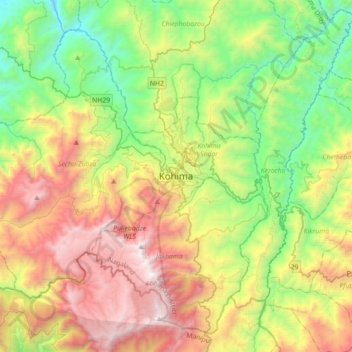
Nome: Mapa topográfico Kohima, altitude, relevo.
Local: Kohima, Kohima Sadar, Kohima, Nagaland, 797001, India (25.50188 93.94192 25.82188 94.26192)
Altitude média: 1425 m
Altitude mínima: 430 m
Altitude máxima: 2993 m
Kohima district is the land of the Angami Naga and Rengma Naga tribe. It is situated in the foothills of Japfu range located south of Kohima District (25°40′N 94°07′E / 25.67°N 94.12°E / 25.67; 94.12) and has an average elevation of 1,261 metres (4137 feet).