
Mapa topográfico Saqqez
Mapa interativo
Clique no mapa para exibir a altitude.
Sobre este mapa
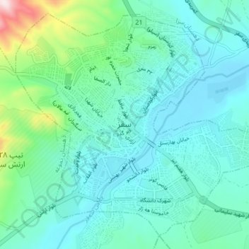
Nome: Mapa topográfico Saqqez, altitude, relevo.
Altitude média: 1527 m
Altitude mínima: 1448 m
Altitude máxima: 1893 m
At an altitude of 1,476 metres (4,842 feet), Saqqez has a Mediterranean continental climate (Köppen climate classification Dsa) with hot, very dry summers and cold, snowy winters. Summers feature large diurnal temperature variation due to decreased air density at high altitude and low humidity. In 1969 Saqqez recorded a temperature of −36 °C (−33 °F), the lowest ever recorded by an Iranian weather station until Kheirabad Zanjan recorded −36.4 °C (−33.5 °F) on January 29, 1997.[13][14] Saqqez again reached −36 °C during the February 3–9 1972 Iran blizzard.
Outros mapas topográficos
Clique em um mapa para visualizar sua topografia, sua altitude e seu relevo.
Suteh
Iran > Kurdistan Province > Saqqez County > دهستان چهل چشمه غربی
Suteh, دهستان چهل چشمه غربی, بخش سرشیو, Saqqez County, Kurdistan Province, Iran
Altitude média: 1779 m
Bastam
Iran > Kurdistan Province > Saqqez County > دهستان چهل چشمه غربی
Bastam, دهستان چهل چشمه غربی, بخش سرشیو, Saqqez County, Kurdistan Province, Iran
Altitude média: 1793 m
Irab
Iran > Kurdistan Province > Saqqez County > دهستان امام > Irab
Irab, دهستان امام, بخش امام, Saqqez County, Kurdistan Province, Iran
Altitude média: 1788 m