
Mapa topográfico Klausenpass
Mapa interativo
Clique no mapa para exibir a altitude.
Sobre este mapa
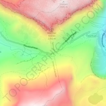
Nome: Mapa topográfico Klausenpass, altitude, relevo.
Local: Klausenpass, Unterschächen, Uri, 6465, Switzerland (46.86814 8.85539 46.86824 8.85549)
Altitude média: 2103 m
Altitude mínima: 1631 m
Altitude máxima: 2509 m
Klausen Pass (German: Klausenpass; elevation: 1,948 metres or 6,391 feet) is a high mountain pass in the Swiss Alps connecting Altdorf in the canton of Uri with Linthal in the canton of Glarus. Somewhat unusually, the boundary between the two cantons does not lie at the summit of the pass, but some 8 kilometres (5.0 mi) down the slope towards Linthal, with the summit being in Uri.
Outros mapas topográficos
Clique em um mapa para visualizar sua topografia, sua altitude e seu relevo.
Oberalp
Switzerland > Uri > Unterschächen
Oberalp, Unterschächen, Uri, 6465, Switzerland
Altitude média: 1900 m