
Mapa topográfico Alfred
Mapa interativo
Clique no mapa para exibir a altitude.
Sobre este mapa
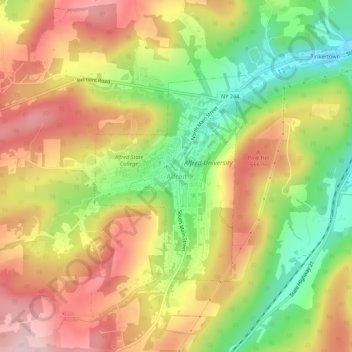
Nome: Mapa topográfico Alfred, altitude, relevo.
Altitude média: 604 m
Altitude mínima: 484 m
Altitude máxima: 712 m
The elevation of Alfred is about 1,700 feet (520 m) but rises to a high point of 2,355 feet (718 m) at the summit of Jericho Hill just south of the village. The hills greatly affect the weather in the region, which results in quick changes as well as different conditions in neighboring valleys.