
Mapa topográfico Leadville
Mapa interativo
Clique no mapa para exibir a altitude.
Sobre este mapa
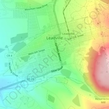
Nome: Mapa topográfico Leadville, altitude, relevo.
Local: Leadville, Lake County, Colorado, 80461, United States (39.23730 -106.30754 39.25598 -106.27958)
Altitude média: 3106 m
Altitude mínima: 3023 m
Altitude máxima: 3247 m
The City of Leadville is a statutory city that is the county seat, the most populous community, and the only incorporated municipality in Lake County, Colorado, United States. The city population was 2,602 at the 2010 census and an estimated 2,762 in 2018. It is situated at an elevation of 10,152 feet (3,094 m). Leadville is the highest incorporated city in the United States and it is surrounded by two of the tallest 14,000 foot peaks in the state.
Outros mapas topográficos
Clique em um mapa para visualizar sua topografia, sua altitude e seu relevo.
Leadville
United States > Colorado > Lake County
Leadville, Lake County, Colorado, 80461, United States
Altitude média: 3106 m
Leadville North
United States > Colorado > Lake County > Leadville
Leadville North, Leadville, Lake County, Colorado, United States
Altitude média: 3040 m
Crystal Lakes
United States > Colorado > Lake County
Crystal Lakes, Lake County, Colorado, United States
Altitude média: 2899 m
Lake Creek
United States > Colorado > Lake County
Lake Creek, Lake County, Colorado, 81251, United States
Altitude média: 3293 m
Hagerman Lake
United States > Colorado > Lake County
Hagerman Lake, Lake County, Colorado, United States
Altitude média: 3484 m
Lake Isabelle
United States > Colorado > Lake County
Lake Isabelle, Lake County, Colorado, United States
Altitude média: 3600 m
Mount Elbert
United States > Colorado > Lake County
Mount Elbert, Lake County, Colorado, United States
Altitude média: 3958 m
Mount Sherman
United States > Colorado > Lake County
Mount Sherman, Lake County, Colorado, United States
Altitude média: 3989 m