
Faça uma doação
Prepare-se para a sua próxima aventura:
Como Associado da Amazon, este site recebe uma comissão sobre compras elegíveis sem custo adicional para si.
Mapa topográfico Olympia
Clique no mapa para exibir a altitude.
Faça uma doação
Prepare-se para a sua próxima aventura:
Como Associado da Amazon, este site recebe uma comissão sobre compras elegíveis sem custo adicional para si.
Olympia
The area is located near the southern limit of the Fraser Glaciation and the underlying sediments consist largely of Vashon-age till and outwash deposited at that time; the area also includes former lakebeds and alluvial deposits associated with proglacial lakes that existed in the area near the end of Vashon-stage glaciation. Residual glacial topography in the area includes drumlins, subglacial channels, and kettle lakes. Much of downtown Olympia sits on reclaimed land. Tidewater areas were filled as early as the 1870s, but the major change occurred in 1910–11 with placement of the Carlyon Fill (named for mayor P.H. Carlyon). Over two million cubic yards of sediment were dredged, thereby creating a deep-water port at Olympia; the dredged material was used to fill tidelands, creating almost 30 blocks of what is now downtown.
Faça uma doação
Prepare-se para a sua próxima aventura:
Como Associado da Amazon, este site recebe uma comissão sobre compras elegíveis sem custo adicional para si.
Sobre este mapa
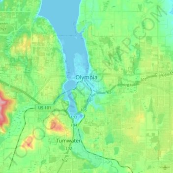
Nome: Mapa topográfico Olympia, altitude, relevo.
Local: Olympia, Thurston County, Washington, United States (47.00086 -122.97108 47.07826 -122.82325)
Altitude média: 49 m
Altitude mínima: -1 m
Altitude máxima: 175 m
Faça uma doação
Prepare-se para a sua próxima aventura:
Como Associado da Amazon, este site recebe uma comissão sobre compras elegíveis sem custo adicional para si.