
Faça uma doação
Prepare-se para a sua próxima aventura:
Como Associado da Amazon, este site recebe uma comissão sobre compras elegíveis sem custo adicional para si.
Mapa topográfico Needham
Clique no mapa para exibir a altitude.
Faça uma doação
Prepare-se para a sua próxima aventura:
Como Associado da Amazon, este site recebe uma comissão sobre compras elegíveis sem custo adicional para si.
Needham
Needham's area is roughly in the shape of an acute, northward-pointing triangle. The Charles River forms nearly all of the southern and northeastern boundaries, the town line with Wellesley forming the third, northwestern one. In addition to Wellesley on the northwest, Needham borders Newton and the West Roxbury section of Boston on the northeast, and Dover, Westwood, and Dedham on the south. The majority of Cutler Park is in Needham and is located along the Charles River and the border with Newton and West Roxbury. Elevations in Needham range from 85 feet above sea level at Rosemary Meadows to 180 feet at Needham Square and 300 feet at Bird's Hill.
Faça uma doação
Prepare-se para a sua próxima aventura:
Como Associado da Amazon, este site recebe uma comissão sobre compras elegíveis sem custo adicional para si.
Sobre este mapa
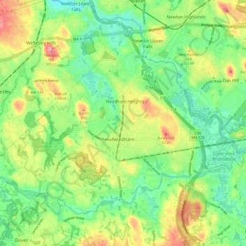
Nome: Mapa topográfico Needham, altitude, relevo.
Local: Needham, Norfolk County, Massachusetts, United States (42.25484 -71.30127 42.31652 -71.18820)
Altitude média: 46 m
Altitude mínima: 11 m
Altitude máxima: 98 m
Faça uma doação
Prepare-se para a sua próxima aventura:
Como Associado da Amazon, este site recebe uma comissão sobre compras elegíveis sem custo adicional para si.
Outros mapas topográficos
Clique em um mapa para visualizar sua topografia, sua altitude e seu relevo.
Faça uma doação
Prepare-se para a sua próxima aventura:
Como Associado da Amazon, este site recebe uma comissão sobre compras elegíveis sem custo adicional para si.