
Mapa topográfico Negros Oriental
Mapa interativo
Clique no mapa para exibir a altitude.
Sobre este mapa
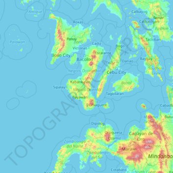
Nome: Mapa topográfico Negros Oriental, altitude, relevo.
Local: Negros Oriental, Central Visayas, Philippines (7.19000 120.44000 12.31000 125.56000)
Altitude média: 101 m
Altitude mínima: -2 m
Altitude máxima: 2797 m
The province's topography is characterized by low, grooved mountain ranges of which some lie close to the shoreline. At the southern end of the province is Mount Talinis, also known as Cuernos de Negros ("Horns of Negros"), which is a dormant complex volcano which rises to a height of 2,000 metres (6,600 ft). At the northern end of the province is the active Kanlaon Volcano, the highest peak of the island region with a height of 2,465 metres (8,087 ft). There are a few flatlands and plateaus in the interior to the southwest of the province, which includes the Tablas Plateau.
Outros mapas topográficos
Clique em um mapa para visualizar sua topografia, sua altitude e seu relevo.
Lake Danao
Philippines > Negros Oriental > Sibulan
Lake Danao, Sibulan, Negros Oriental, Central Visayas, Philippines
Altitude média: 956 m
Dumaguete
Dumaguete, Negros Oriental, Central Visayas, 6200, Philippines
Altitude média: 55 m
Bacong
Bacong, Negros Oriental, Central Visayas, 6216, Philippines
Altitude média: 36 m
Manjuyod
Philippines > Negros Oriental > Manjuyod
Manjuyod, Negros Oriental, Central Visayas, Philippines
Altitude média: 72 m
Canlaon
Philippines > Negros Oriental > Canlaon
Canlaon, Negros Oriental, Central Visayas, 6223, Philippines
Altitude média: 428 m