
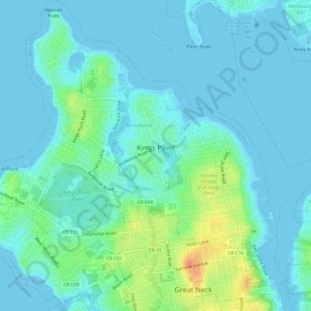
Mapa topográfico Village of Kings Point
Mapa interativo
Clique no mapa para exibir a altitude.
Sobre este mapa
Nome: Mapa topográfico Village of Kings Point, altitude, relevo.
Altitude média: 9 m
Altitude mínima: -3 m
Altitude máxima: 46 m
Outros mapas topográficos
Clique em um mapa para visualizar sua topografia, sua altitude e seu relevo.
Village of Lattingtown
États-Unis d'Amérique > New York > Nassau County
Village of Lattingtown, Town of Oyster Bay, Nassau County, New York, 11560, États-Unis d'Amérique
Altitude média: 20 m
Village of Island Park
États-Unis d'Amérique > New York > Nassau County
Village of Island Park, Town of Hempstead, Nassau County, New York, 11558, États-Unis d'Amérique
Altitude média: 1 m
Village of Lynbrook
États-Unis d'Amérique > New York > Nassau County
Village of Lynbrook, Town of Hempstead, Nassau County, New York, 11563, États-Unis d'Amérique
Altitude média: 8 m
Village of Mineola
États-Unis d'Amérique > New York > Nassau County
Village of Mineola, Town of North Hempstead, Nassau County, New York, 11501, États-Unis d'Amérique
Altitude média: 35 m
Glen Head
États-Unis d'Amérique > New York > Nassau County
Glen Head, Town of Oyster Bay, Nassau County, New York, États-Unis d'Amérique
Altitude média: 40 m
Village of Westbury
États-Unis d'Amérique > New York > Nassau County
Village of Westbury, Town of North Hempstead, Nassau County, New York, États-Unis d'Amérique
Altitude média: 39 m
Village of Rockville Centre
États-Unis d'Amérique > New York > Nassau County
Village of Rockville Centre, Town of Hempstead, Nassau County, New York, 11570, États-Unis d'Amérique
Altitude média: 11 m