
Mapa topográfico Kittson County
Mapa interativo
Clique no mapa para exibir a altitude.
Sobre este mapa
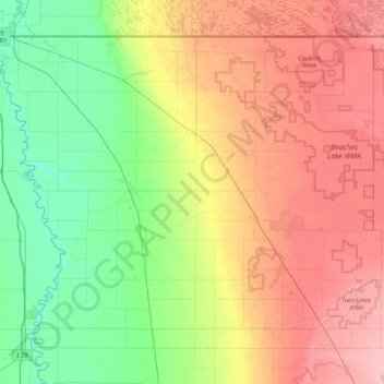
Nome: Mapa topográfico Kittson County, altitude, relevo.
Local: Kittson County, Minnesota, United States (48.54326 -97.23926 49.00050 -96.38699)
Altitude média: 275 m
Altitude mínima: 233 m
Altitude máxima: 334 m
Kittson County was once part of glacial Lake Agassiz. Evidence of this prehistoric lake can still be seen in the county's topography. Remnants of McCauleyville Beach can be found in the eastern part of the county, an area of sandy soil and sand ridges. Other evidence of the glacier and Lake Agassiz is the approximately 140' drop in elevation from the eastern part of the county to the western part, near the Red River Valley, with its proliferation of black rich soil. Lake Bronson is a manmade reservoir, completed in 1937.
Outros mapas topográficos
Clique em um mapa para visualizar sua topografia, sua altitude e seu relevo.
Minneapolis
United States > Minnesota > Hennepin County
Minneapolis, Hennepin County, Minnesota, United States
Altitude média: 270 m
Saint Paul
United States > Minnesota > Ramsey County
Saint Paul, Ramsey County, Minnesota, United States
Altitude média: 268 m
Rochester
United States > Minnesota > Olmsted County
Rochester, Olmsted County, Minnesota, United States
Altitude média: 354 m
Minneapolis
United States > Minnesota > Hennepin County > Minneapolis
Minneapolis, Hennepin County, Minnesota, 55488, United States
Altitude média: 271 m
Big Moose Lake
United States > Minnesota > Saint Louis County
Big Moose Lake, Northeast St Louis, Saint Louis County, Minnesota, United States
Altitude média: 432 m
Mankato
United States > Minnesota > Blue Earth County
Mankato, Blue Earth County, Minnesota, 56001, United States
Altitude média: 285 m
Duluth
United States > Minnesota > Saint Louis County
Duluth, Saint Louis County, Minnesota, United States
Altitude média: 286 m
Bloomington
United States > Minnesota > Hennepin County
Bloomington, Hennepin County, Minnesota, United States
Altitude média: 255 m
Olmsted County
Olmsted County, Minnesota, United States
Altitude média: 354 m
Maple Grove
United States > Minnesota > Hennepin County
Maple Grove, Hennepin County, Minnesota, United States
Altitude média: 278 m
Crow Wing County
Crow Wing County, Minnesota, United States
Altitude média: 386 m
Eagan
United States > Minnesota > Dakota County
Eagan, Dakota County, Minnesota, United States
Altitude média: 267 m
Bonnevista Terrace Mobile Home Park
United States > Minnesota > Scott County
Bonnevista Terrace Mobile Home Park, Jackson Township, Scott County, Minnesota, United States
Altitude média: 241 m
Washington County
Washington County, Minnesota, United States
Altitude média: 283 m
Hills
United States > Minnesota > Rock County
Hills, Martin Township, Rock County, Minnesota, 56138, United States
Altitude média: 445 m
Green Lake
United States > Minnesota > Beltrami County > Little Rock
Green Lake, Little Rock, Beltrami County, Minnesota, United States
Altitude média: 379 m
Grey Cloud Island
United States > Minnesota > Washington County > Grey Cloud Island Township
Grey Cloud Island, Grey Cloud Island Township, Washington County, Minnesota, 55071, United States
Altitude média: 225 m
West St. Paul
United States > Minnesota > Dakota County
West St. Paul, Dakota County, Minnesota, 55118, United States
Altitude média: 294 m
Bemidji
United States > Minnesota > Beltrami County
Bemidji, Beltrami County, Minnesota, 56601, United States
Altitude média: 417 m
Dunnell
United States > Minnesota > Martin County
Dunnell, Martin County, Minnesota, United States
Altitude média: 403 m
Gainy Park
United States > Minnesota > Steele County > Owatonna
Gainy Park, Owatonna, Steele County, Minnesota, United States
Altitude média: 359 m
Glendale
United States > Minnesota > Scott County > Savage
Glendale, Savage, Scott County, Minnesota, 55378, United States
Altitude média: 262 m
Sherburne County
Sherburne County, Minnesota, United States
Altitude média: 298 m
Stillwater
United States > Minnesota > Washington County
Stillwater, Washington County, Minnesota, United States
Altitude média: 259 m
Big Deep Lake
United States > Minnesota > Cass County
Big Deep Lake, Cass County, Minnesota, United States
Altitude média: 420 m
Bodum
United States > Minnesota > Isanti County
Bodum, Isanti Township, Isanti County, Minnesota, 55008, United States
Altitude média: 294 m
Oxlip
United States > Minnesota > Isanti County
Oxlip, Bradford Township, Isanti County, Minnesota, United States
Altitude média: 288 m
Crown
United States > Minnesota > Isanti County
Crown, Stanford Township, Isanti County, Minnesota, United States
Altitude média: 295 m
Weber
United States > Minnesota > Isanti County
Weber, North Branch Township, Isanti County, Minnesota, United States
Altitude média: 282 m
Walbo
United States > Minnesota > Isanti County
Walbo, Springvale Township, Isanti County, Minnesota, United States
Altitude média: 286 m
Springvale
United States > Minnesota > Isanti County
Springvale, Springvale Township, Isanti County, Minnesota, United States
Altitude média: 288 m
Pine Brook
United States > Minnesota > Isanti County
Pine Brook, Springvale Township, Isanti County, Minnesota, United States
Altitude média: 291 m
Grandy
United States > Minnesota > Isanti County
Grandy, Cambridge Township, Isanti County, Minnesota, 55029, United States
Altitude média: 285 m
Elm Park
United States > Minnesota > Isanti County
Elm Park, Maple Ridge Township, Isanti County, Minnesota, United States
Altitude média: 290 m
Carmody
United States > Minnesota > Isanti County
Carmody, Dalbo Township, Isanti County, Minnesota, 55017, United States
Altitude média: 299 m
Stanchfield
United States > Minnesota > Isanti County
Stanchfield, Stanchfield Township, Isanti County, Minnesota, 55080, United States
Altitude média: 287 m
Wyanett
United States > Minnesota > Isanti County
Wyanett, Wyanett Township, Isanti County, Minnesota, United States
Altitude média: 293 m
West Point
United States > Minnesota > Isanti County
West Point, Spencer Brook Township, Isanti County, Minnesota, United States
Altitude média: 287 m
Stanley
United States > Minnesota > Isanti County
Stanley, Isanti Township, Isanti County, Minnesota, United States
Altitude média: 293 m
Stanchfield Corner
United States > Minnesota > Isanti County
Stanchfield Corner, Stanchfield Township, Isanti County, Minnesota, 55080, United States
Altitude média: 287 m
Spring Lake
United States > Minnesota > Isanti County
Spring Lake, North Branch Township, Isanti County, Minnesota, United States
Altitude média: 286 m
Spencer Brook
United States > Minnesota > Isanti County
Spencer Brook, Spencer Brook Township, Isanti County, Minnesota, United States
Altitude média: 289 m
Edgewood
United States > Minnesota > Isanti County
Edgewood, Isanti Township, Isanti County, Minnesota, 55008, United States
Altitude média: 289 m
Day
United States > Minnesota > Isanti County
Day, Maple Ridge Township, Isanti County, Minnesota, United States
Altitude média: 302 m
Dalbo
United States > Minnesota > Isanti County
Dalbo, Dalbo Township, Isanti County, Minnesota, 55017, United States
Altitude média: 296 m
Blomford
United States > Minnesota > Isanti County
Blomford, Isanti Township, Isanti County, Minnesota, United States
Altitude média: 290 m
Andree
United States > Minnesota > Isanti County
Andree, Stanchfield Township, Isanti County, Minnesota, 55006, United States
Altitude média: 291 m
Isanti
United States > Minnesota > Isanti County
Isanti, Isanti County, Minnesota, United States
Altitude média: 285 m