
Mapa topográfico Kirchseelte
Mapa interativo
Clique no mapa para exibir a altitude.
Sobre este mapa
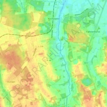
Nome: Mapa topográfico Kirchseelte, altitude, relevo.
Altitude média: 30 m
Altitude mínima: 12 m
Altitude máxima: 46 m
Outros mapas topográficos
Clique em um mapa para visualizar sua topografia, sua altitude e seu relevo.
Dünsen
Germany > Lower Saxony > Landkreis Oldenburg
Dünsen, Samtgemeinde Harpstedt, Landkreis Oldenburg, Lower Saxony, Germany
Altitude média: 38 m
Dötlingen
Germany > Lower Saxony > Landkreis Oldenburg > Dötlingen
Dötlingen, Landkreis Oldenburg, Lower Saxony, 27801, Germany
Altitude média: 31 m
Wildeshausen
Germany > Lower Saxony > Landkreis Oldenburg
Wildeshausen, Landkreis Oldenburg, Lower Saxony, 27793, Germany
Altitude média: 37 m