
Mapa topográfico Lusaka
Mapa interativo
Clique no mapa para exibir a altitude.
Sobre este mapa
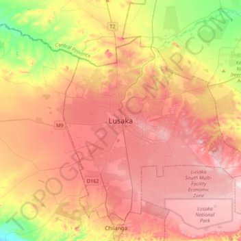
Nome: Mapa topográfico Lusaka, altitude, relevo.
Local: Lusaka, Lusaka District, Lusaka Province, 10101, Zambia (-15.57634 28.12184 -15.25634 28.44184)
Altitude média: 1227 m
Altitude mínima: 1064 m
Altitude máxima: 1349 m
Lusaka (/luːˈsɑːkə/; loo-SAH-kə) is the capital and largest city of Zambia. It is one of the fastest-developing cities in southern Africa. Lusaka is in the southern part of the central plateau at an elevation of about 1,279 metres (4,196 ft). As of 2019, the city's population was about 3.3 million, while the urban population is estimated at 2.5 million in 2018. Lusaka is the centre of both commerce and government in Zambia and connects to the country's four main highways heading north, south, east and west. English is the official language of the city administration, while Bemba, Tonga, Lenje, Soli, Lozi and Nyanja are the commonly spoken street languages.
Outros mapas topográficos
Clique em um mapa para visualizar sua topografia, sua altitude e seu relevo.
Kafue
Zambia > Lusaka Province > Kafue
Kafue, Kafue District, Lusaka Province, Zambia
Altitude média: 1028 m
Mwembeshi
Mwembeshi, Chilanga District, Lusaka Province, Zambia
Altitude média: 1108 m