
Faça uma doação
Prepare-se para a sua próxima aventura:
Como Associado da Amazon, este site recebe uma comissão sobre compras elegíveis sem custo adicional para si.
Mapa topográfico Gap
Clique no mapa para exibir a altitude.
Faça uma doação
Prepare-se para a sua próxima aventura:
Como Associado da Amazon, este site recebe uma comissão sobre compras elegíveis sem custo adicional para si.
Gap
The cover of morainic debris is omnipresent in the Sillon de Gap but is not the only vestige of the Quaternary glaciation. There is also the typical topography of glacial valleys. The location of the town of Gap corresponds to an Ombilic glaciaire, where large quantities of clay were deposited. Upstream lies the Verrou glaciaire [fr] [glacial lock] of Pont-Sarrazin and downstream of Tourronde.
Faça uma doação
Prepare-se para a sua próxima aventura:
Como Associado da Amazon, este site recebe uma comissão sobre compras elegíveis sem custo adicional para si.
Sobre este mapa
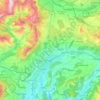
Nome: Mapa topográfico Gap, altitude, relevo.
Altitude média: 1146 m
Altitude mínima: 629 m
Altitude máxima: 2374 m
Faça uma doação
Prepare-se para a sua próxima aventura:
Como Associado da Amazon, este site recebe uma comissão sobre compras elegíveis sem custo adicional para si.
Outros mapas topográficos
Clique em um mapa para visualizar sua topografia, sua altitude e seu relevo.
Serre Chevalier
France > Provence-Alpes-Côte d'Azur > Hautes-Alpes > Puy-Saint-André
The maximum elevation for skiing is at Telesiege Yret at 2,800 m (9,190 ft) above sea level, and the minimum is 1,200 m (3,940 ft), a total vertical drop of 1,600 m (5,250 ft). One of the outstanding features of Serre Chevalier is the wooded nature of the slopes. The timber line is at 2,150 m (7,050 ft),…
Altitude média: 2256 m
Col du Lautaret
France > Provence-Alpes-Côte d'Azur > Hautes-Alpes > Le Monêtier-les-Bains
From the west, the climb starts at Les Clapier, near Le Bourg-d'Oisans, from where the climb is 34.2 km (21.3 mi) long, gaining 1,312 m (4,304 ft) in altitude, at an average gradient of 3.8%, with the steepest section being at 7.5% in the first kilometre.
Altitude média: 2261 m
Lucis
France > Provence-Alpes-Côte d'Azur > Hautes-Alpes > Villar-Saint-Pancrace
Altitude média: 1326 m
Faça uma doação
Prepare-se para a sua próxima aventura:
Como Associado da Amazon, este site recebe uma comissão sobre compras elegíveis sem custo adicional para si.
Orcières-Merlette
France > Provence-Alpes-Côte d'Azur > Hautes-Alpes > Orcières
Altitude média: 1874 m
Plan de la Loubiere
France > Provence-Alpes-Côte d'Azur > Hautes-Alpes > La Roche-de-Rame
Altitude média: 2056 m
Les Chaussendents
France > Provence-Alpes-Côte d'Azur > Hautes-Alpes > La Chapelle-en-Valgaudémar
Altitude média: 1619 m
Faça uma doação
Prepare-se para a sua próxima aventura:
Como Associado da Amazon, este site recebe uma comissão sobre compras elegíveis sem custo adicional para si.
Faça uma doação
Prepare-se para a sua próxima aventura:
Como Associado da Amazon, este site recebe uma comissão sobre compras elegíveis sem custo adicional para si.
Station de Ski de Réallon
France > Provence-Alpes-Côte d'Azur > Hautes-Alpes > Réallon
Altitude média: 1494 m
Les Allouviers
France > Provence-Alpes-Côte d'Azur > Hautes-Alpes > Gap > Romette
Altitude média: 957 m
Les Payas
France > Provence-Alpes-Côte d'Azur > Hautes-Alpes > Saint-Bonnet-en-Champsaur
Altitude média: 1325 m
Faça uma doação
Prepare-se para a sua próxima aventura:
Como Associado da Amazon, este site recebe uma comissão sobre compras elegíveis sem custo adicional para si.
Le Château d'Ancelle
France > Provence-Alpes-Côte d'Azur > Hautes-Alpes > Ancelle
Altitude média: 1407 m
Les Forests
France > Provence-Alpes-Côte d'Azur > Hautes-Alpes > Saint-Léger-les-Mélèzes
Altitude média: 1383 m