
Faça uma doação
Prepare-se para a sua próxima aventura:
Como Associado da Amazon, este site recebe uma comissão sobre compras elegíveis sem custo adicional para si.
Mapa topográfico Fort St. John
Clique no mapa para exibir a altitude.
Faça uma doação
Prepare-se para a sua próxima aventura:
Como Associado da Amazon, este site recebe uma comissão sobre compras elegíveis sem custo adicional para si.
Fort St. John
Sitting at an elevation of 690 m (2,260 ft), Fort Saint John is situated within a low-lying valley near the eastern foothills of the Muskwa Ranges and Hart Ranges of the Northern Rockies. Prairies lie to the east and north, while to the west the Rocky Mountains form a rain shadow. The city is built on relatively flat, rolling hills.
Faça uma doação
Prepare-se para a sua próxima aventura:
Como Associado da Amazon, este site recebe uma comissão sobre compras elegíveis sem custo adicional para si.
Sobre este mapa
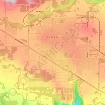
Nome: Mapa topográfico Fort St. John, altitude, relevo.
Altitude média: 676 m
Altitude mínima: 493 m
Altitude máxima: 780 m
Faça uma doação
Prepare-se para a sua próxima aventura:
Como Associado da Amazon, este site recebe uma comissão sobre compras elegíveis sem custo adicional para si.
Outros mapas topográficos
Clique em um mapa para visualizar sua topografia, sua altitude e seu relevo.
Cassiar Mountains
Canada > British Columbia > Peace River Regional District > Area B (Finlay Valley/Beatton Valley)
Altitude média: 935 m
Pine River
Canada > British Columbia > Peace River Regional District > Area E (Moberly Lake/Sukunka Valley)
Altitude média: 973 m
Parkland
Canada > British Columbia > Peace River Regional District > Area D (Kiskatinaw Valley)
Altitude média: 726 m
Jack Lake
Canada > British Columbia > Peace River Regional District > Area B (Finlay Valley/Beatton Valley)
Altitude média: 996 m
Faça uma doação
Prepare-se para a sua próxima aventura:
Como Associado da Amazon, este site recebe uma comissão sobre compras elegíveis sem custo adicional para si.
Crescent Park
Canada > British Columbia > Peace River Regional District > Dawson Creek
Altitude média: 687 m
Milligan Hills
Canada > British Columbia > Peace River Regional District > Area B (Finlay Valley/Beatton Valley)
Altitude média: 891 m
Carbon Peak
Canada > British Columbia > Peace River Regional District > Area E (Moberly Lake/Sukunka Valley)
Altitude média: 1421 m
Attachie
Canada > British Columbia > Peace River Regional District > Area B (Finlay Valley/Beatton Valley)
Altitude média: 477 m
Faça uma doação
Prepare-se para a sua próxima aventura:
Como Associado da Amazon, este site recebe uma comissão sobre compras elegíveis sem custo adicional para si.
Rocky Mountains
Canada > British Columbia > Peace River Regional District > Area D (Kiskatinaw Valley)
Altitude média: 1458 m
Groundbirch
Canada > British Columbia > Peace River Regional District > Area E (Moberly Lake/Sukunka Valley)
Altitude média: 741 m
Montney
Canada > British Columbia > Peace River Regional District > Area B (Finlay Valley/Beatton Valley)
It lies at an elevation of 700 meters (2,300 ft), along the BC Rail tracks.
Altitude média: 718 m
Mount Russel
Canada > British Columbia > Peace River Regional District > Area B (Finlay Valley/Beatton Valley)
Altitude média: 1651 m
Faça uma doação
Prepare-se para a sua próxima aventura:
Como Associado da Amazon, este site recebe uma comissão sobre compras elegíveis sem custo adicional para si.
Windfall Lake
Canada > British Columbia > Peace River Regional District > Area E (Moberly Lake/Sukunka Valley)
Altitude média: 1655 m
Buckinghorse River
Canada > British Columbia > Peace River Regional District > Area B (Finlay Valley/Beatton Valley)
Altitude média: 945 m
Beaver Lake
Canada > British Columbia > Peace River Regional District > Area E (Moberly Lake/Sukunka Valley)
Altitude média: 692 m
Mount Ulysses
Canada > British Columbia > Peace River Regional District > Area B (Finlay Valley/Beatton Valley)
Altitude média: 2355 m
Faça uma doação
Prepare-se para a sua próxima aventura:
Como Associado da Amazon, este site recebe uma comissão sobre compras elegíveis sem custo adicional para si.
Pine Valley
Canada > British Columbia > Peace River Regional District > Area D (Kiskatinaw Valley)
Altitude média: 766 m
Milligan Hills Provincial Park
Canada > British Columbia > Peace River Regional District > Area B (Finlay Valley/Beatton Valley)
Altitude média: 875 m
Martin Falls
Canada > British Columbia > Peace River Regional District > Area E (Moberly Lake/Sukunka Valley)
Altitude média: 763 m
Charlie Lake
Canada > British Columbia > Peace River Regional District > Area B (Finlay Valley/Beatton Valley)
Altitude média: 761 m
Faça uma doação
Prepare-se para a sua próxima aventura:
Como Associado da Amazon, este site recebe uma comissão sobre compras elegíveis sem custo adicional para si.
Indian Head
Canada > British Columbia > Peace River Regional District > Area E (Moberly Lake/Sukunka Valley)
Altitude média: 1101 m
Omineca Mountains
Canada > British Columbia > Peace River Regional District > Area B (Finlay Valley/Beatton Valley)
Altitude média: 1010 m
Mount Jarvis
Canada > British Columbia > Peace River Regional District > Area D (Kiskatinaw Valley)
Altitude média: 1777 m
Rocky Mountains
Canada > British Columbia > Peace River Regional District > Area B (Finlay Valley/Beatton Valley)
Altitude média: 1019 m
Faça uma doação
Prepare-se para a sua próxima aventura:
Como Associado da Amazon, este site recebe uma comissão sobre compras elegíveis sem custo adicional para si.
Obo Lake
Canada > British Columbia > Peace River Regional District > Area B (Finlay Valley/Beatton Valley)
Altitude média: 1300 m
Clayhurst
Canada > British Columbia > Peace River Regional District > Area B (Finlay Valley/Beatton Valley)
Altitude média: 644 m
Fort St. John
Canada > British Columbia > Peace River Regional District > Fort St. John
Altitude média: 650 m
East Pine
Canada > British Columbia > Peace River Regional District > Area E (Moberly Lake/Sukunka Valley)
Altitude média: 664 m
Faça uma doação
Prepare-se para a sua próxima aventura:
Como Associado da Amazon, este site recebe uma comissão sobre compras elegíveis sem custo adicional para si.
Buckinghorse River
Canada > British Columbia > Peace River Regional District > Area B (Finlay Valley/Beatton Valley)
Altitude média: 1200 m
Rocky Mountains
Canada > British Columbia > Peace River Regional District > Area B (Finlay Valley/Beatton Valley)
Altitude média: 1221 m
Rocky Mountains
Canada > British Columbia > Peace River Regional District > Area B (Finlay Valley/Beatton Valley)
Altitude média: 1221 m
Rocky Mountains
Canada > British Columbia > Peace River Regional District > Area B (Finlay Valley/Beatton Valley)
Altitude média: 986 m
Faça uma doação
Prepare-se para a sua próxima aventura:
Como Associado da Amazon, este site recebe uma comissão sobre compras elegíveis sem custo adicional para si.
Rocky Mountains
Canada > British Columbia > Peace River Regional District > Area E (Moberly Lake/Sukunka Valley)
Altitude média: 1462 m
Site C Dam
Canada > British Columbia > Peace River Regional District > Area E (Moberly Lake/Sukunka Valley)
Altitude média: 483 m
Rocky Mountains
Canada > British Columbia > Peace River Regional District > Area B (Finlay Valley/Beatton Valley)
Altitude média: 870 m
Horsetail Falls
Canada > British Columbia > Peace River Regional District > Area E (Moberly Lake/Sukunka Valley)
Altitude média: 1024 m
Faça uma doação
Prepare-se para a sua próxima aventura:
Como Associado da Amazon, este site recebe uma comissão sobre compras elegíveis sem custo adicional para si.
Brandon Peak
Canada > British Columbia > Peace River Regional District > Area B (Finlay Valley/Beatton Valley)
Altitude média: 1801 m
Rocky Mountains
Canada > British Columbia > Peace River Regional District > Area D (Kiskatinaw Valley)
Altitude média: 1252 m
Rocky Mountains
Canada > British Columbia > Peace River Regional District > Area E (Moberly Lake/Sukunka Valley)
Altitude média: 1462 m