
Faça uma doação
Prepare-se para a sua próxima aventura:
Como Associado da Amazon, este site recebe uma comissão sobre compras elegíveis sem custo adicional para si.
Mapa topográfico Qom
Clique no mapa para exibir a altitude.
Faça uma doação
Prepare-se para a sua próxima aventura:
Como Associado da Amazon, este site recebe uma comissão sobre compras elegíveis sem custo adicional para si.
Qom
The city's topography in the 10th century still reflected the evolutionary merging of the original six villages; these were still separated by fields. The town center was located in the village of Mamajjān, which was connected to other parts of the city on the other side of the river by four bridges. There were about eight squares whose function is not clear and three mosques within the city. There is almost no information about madrasas. The sanctuary must have still been quite small as only two cupolas are mentioned. A bazaar and bathhouses must have existed, too, as well as certain administrative buildings (prison, mint). Five bigger and eight smaller roads indicate good traffic connections, which were supported by at least three or maybe even nine city gates.
Faça uma doação
Prepare-se para a sua próxima aventura:
Como Associado da Amazon, este site recebe uma comissão sobre compras elegíveis sem custo adicional para si.
Sobre este mapa
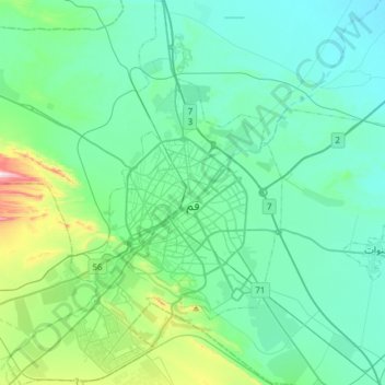
Nome: Mapa topográfico Qom, altitude, relevo.
Local: Qom, Qom Central District, Qom County, Qom Province, Iran (34.52552 50.73317 34.77500 50.95022)
Altitude média: 943 m
Altitude mínima: 846 m
Altitude máxima: 1440 m
Faça uma doação
Prepare-se para a sua próxima aventura:
Como Associado da Amazon, este site recebe uma comissão sobre compras elegíveis sem custo adicional para si.