
Faça uma doação
Prepare-se para a sua próxima aventura:
Como Associado da Amazon, este site recebe uma comissão sobre compras elegíveis sem custo adicional para si.
Mapa topográfico Mount Penanggungan
Clique no mapa para exibir a altitude.
Faça uma doação
Prepare-se para a sua próxima aventura:
Como Associado da Amazon, este site recebe uma comissão sobre compras elegíveis sem custo adicional para si.
Mount Penanggungan
There are sub-peaks around Penanggungan, starting to the southeast from Mount Wangi (Gunung Wangi) at 970 meters above sea level, Mount Bekel Jolotundo elevated 1,200 meters ASL, a semi-freestanding peak to the northwest; Puncak Kemuncup rising to 1,200 meters on the eastern face, Puncak Sarah Klopo on the southwestern slope elevated 1,250 meters, Puncak Awang-Awang located about 1,275 meters up the southwestern side, and Puncak Garuda Penanggungan south of the main peak topographing 1,520 meters. Bayangan Hill, located on the southern face at 1,250 meters up, is the main tourist attraction and a scenic spot. The peak is in Mojokerto Regency, with a portion of the slope in Prigen, Pasuruan Regency. As of 3 October 2024, Mt. Penanggungan has 1,213 Google Maps reviews with the quotient of stars to reviews noted to be 4.8.
Faça uma doação
Prepare-se para a sua próxima aventura:
Como Associado da Amazon, este site recebe uma comissão sobre compras elegíveis sem custo adicional para si.
Sobre este mapa
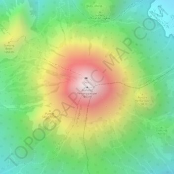
Nome: Mapa topográfico Mount Penanggungan, altitude, relevo.
Altitude média: 1061 m
Altitude mínima: 636 m
Altitude máxima: 1639 m
Faça uma doação
Prepare-se para a sua próxima aventura:
Como Associado da Amazon, este site recebe uma comissão sobre compras elegíveis sem custo adicional para si.