
Mapa topográfico St. Margaret's at Cliffe
Mapa interativo
Clique no mapa para exibir a altitude.
Sobre este mapa
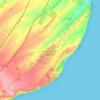
Nome: Mapa topográfico St. Margaret's at Cliffe, altitude, relevo.
Local: St. Margaret's at Cliffe, Dover, Kent, England, United Kingdom (51.13074 1.33161 51.18042 1.40213)
Altitude média: 53 m
Altitude mínima: 0 m
Altitude máxima: 125 m
Outros mapas topográficos
Clique em um mapa para visualizar sua topografia, sua altitude e seu relevo.
White Cliffs of Dover
United Kingdom > England > Kent > Dover > St. Margaret's at Cliffe
White Cliffs of Dover, St. Margaret's at Cliffe, Dover, Kent, England, United Kingdom
Altitude média: 49 m
Sandwich Bay
United Kingdom > England > Kent > Dover
Sandwich Bay, Dover, Kent, England, CT13 9PZ, United Kingdom
Altitude média: 1 m
Claypits
United Kingdom > England > Kent > Dover > Goodnestone
Claypits, Goodnestone, Dover, Kent, England, CT3 1PB, United Kingdom
Altitude média: 34 m
Richborough
United Kingdom > England > Kent > Dover
Richborough, Dover, Kent, England, CT13 9JH, United Kingdom
Altitude média: 4 m
River
United Kingdom > England > Kent > Dover
River, Dover, Kent, England, United Kingdom
Altitude média: 80 m