
Mapa topográfico Kedarnath
Mapa interativo
Clique no mapa para exibir a altitude.
Sobre este mapa
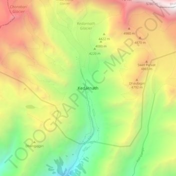
Nome: Mapa topográfico Kedarnath, altitude, relevo.
Local: Kedarnath, Ukhimath, Rudraprayag District, Uttarakhand, India (30.69456 79.02732 30.77456 79.10732)
Altitude média: 4219 m
Altitude mínima: 2761 m
Altitude máxima: 6050 m
Outros mapas topográficos
Clique em um mapa para visualizar sua topografia, sua altitude e seu relevo.
Dilmi
India > Uttarakhand > Ukhimath > Sari
Dilmi, Sari, Ukhimath, Rudraprayag District, Uttarakhand, 246469, India
Altitude média: 1898 m
Uthind
India > Uttarakhand > Ukhimath
Uthind, Ukhimath, Rudraprayag, Uttarakhand, 246419, India
Altitude média: 1601 m
Gaurikund
India > Uttarakhand > Ukhimath
Gaurikund, Ukhimath, Rudraprayag, Uttarakhand, India
Altitude média: 2589 m
Sitapur
India > Uttarakhand > Ukhimath > Sitapur
Sitapur, Ukhimath, Rudraprayag, Uttarakhand, 246471, India
Altitude média: 2062 m
Budha Madmaheshwar
India > Uttarakhand > Ukhimath > Budha Madmaheshwar
Budha Madmaheshwar, Ukhimath, Rudraprayag, Uttarakhand, India
Altitude média: 3045 m
Sonprayag
India > Uttarakhand > Ukhimath > Sonprayag
Sonprayag, Ukhimath, Rudraprayag, Uttarakhand, 246471, India
Altitude média: 2053 m
Madmaheshwar
India > Uttarakhand > Ukhimath > Madmaheshwar
Madmaheshwar, Ukhimath, Rudraprayag, Uttarakhand, India
Altitude média: 3160 m
Chopta Chatti
India > Uttarakhand > Ukhimath > Chopta Chatti
Chopta Chatti, Ukhimath, Rudraprayag, Uttarakhand, India
Altitude média: 2759 m
Rānsi
India > Uttarakhand > Ukhimath > Rānsi
Rānsi, Ukhimath, Rudraprayag, Uttarakhand, India
Altitude média: 2054 m