
Mapa topográfico Bad Zwischenahn
Mapa interativo
Clique no mapa para exibir a altitude.
Sobre este mapa
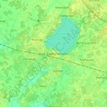
Nome: Mapa topográfico Bad Zwischenahn, altitude, relevo.
Altitude média: 9 m
Altitude mínima: -3 m
Altitude máxima: 17 m
Outros mapas topográficos
Clique em um mapa para visualizar sua topografia, sua altitude e seu relevo.
Edewecht
Germany > Lower Saxony > Landkreis Ammerland
Edewecht, Landkreis Ammerland, Lower Saxony, 26188, Germany
Altitude média: 8 m
Rastede
Germany > Lower Saxony > Landkreis Ammerland
Rastede, Landkreis Ammerland, Lower Saxony, 26180, Germany
Altitude média: 7 m