
Faça uma doação
Prepare-se para a sua próxima aventura:
Como Associado da Amazon, este site recebe uma comissão sobre compras elegíveis sem custo adicional para si.
Mapa topográfico Kaleybar
Clique no mapa para exibir a altitude.
Faça uma doação
Prepare-se para a sua próxima aventura:
Como Associado da Amazon, este site recebe uma comissão sobre compras elegíveis sem custo adicional para si.
Kaleybar
The relatively well preserved Babak Castle at an altitude of 2300 m is located is located some 3 km of the town. This Sasanid era fortress is named after the ninth century Iranian resistance leader, Babak Khorramdin., who resisted Arab armies until year 839.
Faça uma doação
Prepare-se para a sua próxima aventura:
Como Associado da Amazon, este site recebe uma comissão sobre compras elegíveis sem custo adicional para si.
Sobre este mapa
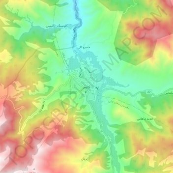
Nome: Mapa topográfico Kaleybar, altitude, relevo.
Altitude média: 1457 m
Altitude mínima: 946 m
Altitude máxima: 2208 m
Faça uma doação
Prepare-se para a sua próxima aventura:
Como Associado da Amazon, este site recebe uma comissão sobre compras elegíveis sem custo adicional para si.