
Mapa topográfico Somercotes CP
Clique no mapa para exibir a altitude.
Sobre este mapa
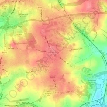
Nome: Mapa topográfico Somercotes CP, altitude, relevo.
Altitude média: 125 m
Altitude mínima: 74 m
Altitude máxima: 154 m
Outros mapas topográficos
Clique em um mapa para visualizar sua topografia, sua altitude e seu relevo.
Heanor
United Kingdom > England > Derbyshire > Amber Valley
Samuel Lewis's A Topographical Dictionary of England, published in 1848, states that Heanor parish "abounds with coal and ironstone, both worked extensively, the collieries alone affording employment to more than 2000 persons. The town is pleasantly situated upon an eminence, on the road from Derby to…
Altitude média: 102 m
Nottingham Canal
United Kingdom > England > Derbyshire > Amber Valley > Langley Mill
Altitude média: 77 m
Alfreton Park
United Kingdom > England > Derbyshire > Amber Valley > Alfreton CP > Oakerthorpe
Altitude média: 116 m
Sawmills
United Kingdom > England > Derbyshire > Amber Valley > Ripley > Fritchley
Altitude média: 119 m
Upper Hartshay
United Kingdom > England > Derbyshire > Amber Valley > Upper Hartshay
Altitude média: 119 m
Farnah Green
United Kingdom > England > Derbyshire > Amber Valley > Blackbrook > Farnah Green
Altitude média: 117 m
Moscow Farm
United Kingdom > England > Derbyshire > Amber Valley > Makeney > Moscow Farm
Altitude média: 103 m
Heanor
United Kingdom > England > Derbyshire > Amber Valley
Samuel Lewis's A Topographical Dictionary of England, published in 1848, states that Heanor parish "abounds with coal and ironstone, both worked extensively, the collieries alone affording employment to more than 2000 persons. The town is pleasantly situated upon an eminence, on the road from Derby to…
Altitude média: 102 m