
Mapa topográfico Sonamarg
Mapa interativo
Clique no mapa para exibir a altitude.
Sonamarg
The hill station is situated in the Kashmir Valley, at an altitude of 2,730 metres (8,960 ft) and is close to some of the valley's tallest peaks, alongside the Machoi Glacier, Sirbal Peak, Kolahoi Peak, Amarnath Peak and Machoi Peak. Combined with the alpine meadows that bloom in the summer as well as rivers and lakes stocked with fish, Sonamarg is a notable tourist destination in Jammu and Kashmir.
Sobre este mapa
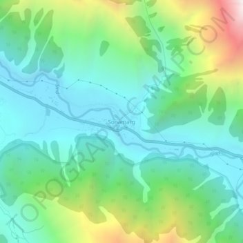
Nome: Mapa topográfico Sonamarg, altitude, relevo.
Local: Sonamarg, Kangan, Ganderbal, Jammu and Kashmir, India (34.28239 75.27656 34.32239 75.31656)
Altitude média: 3068 m
Altitude mínima: 2639 m
Altitude máxima: 4240 m
Outros mapas topográficos
Clique em um mapa para visualizar sua topografia, sua altitude e seu relevo.