
Mapa topográfico Staphorst
Mapa interativo
Clique no mapa para exibir a altitude.
Sobre este mapa
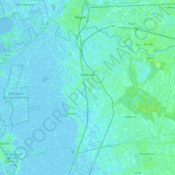
Nome: Mapa topográfico Staphorst, altitude, relevo.
Local: Staphorst, Overijssel, Niederlande (52.58125 6.09592 52.69218 6.32931)
Altitude média: 2 m
Altitude mínima: -5 m
Altitude máxima: 8 m
Outros mapas topográficos
Clique em um mapa para visualizar sua topografia, sua altitude e seu relevo.
IJhorst
Niederlande > Overijssel > Staphorst
IJhorst, Staphorst, Overijssel, Niederlande
Altitude média: 4 m