
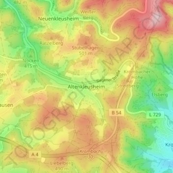
Mapa topográfico Altenkleusheim
Mapa interativo
Clique no mapa para exibir a altitude.
Sobre este mapa
Nome: Mapa topográfico Altenkleusheim, altitude, relevo.
Altitude média: 441 m
Altitude mínima: 315 m
Altitude máxima: 569 m
Outros mapas topográficos
Clique em um mapa para visualizar sua topografia, sua altitude e seu relevo.
Neuenkleusheim
Deutschland > Nordrhein-Westfalen > Kreis Olpe > Olpe
Neuenkleusheim, Olpe, Kreis Olpe, Nordrhein-Westfalen, Deutschland
Altitude média: 447 m
Friedrichsthal
Deutschland > Nordrhein-Westfalen > Kreis Olpe > Olpe
Friedrichsthal, Olpe, Kreis Olpe, Nordrhein-Westfalen, 57462, Deutschland
Altitude média: 389 m
Rhode
Deutschland > Nordrhein-Westfalen > Kreis Olpe > Olpe
Rhode, Olpe, Kreis Olpe, Nordrhein-Westfalen, 57462, Deutschland
Altitude média: 372 m
Schlammborn
Deutschland > Nordrhein-Westfalen > Kreis Olpe > Olpe
Schlammborn, Olpe, Kreis Olpe, Nordrhein-Westfalen, 57462, Deutschland
Altitude média: 394 m
Rüblinghausen
Deutschland > Nordrhein-Westfalen > Kreis Olpe > Olpe
Rüblinghausen, Olpe, Kreis Olpe, Nordrhein-Westfalen, 57462, Deutschland
Altitude média: 371 m
Attenberg
Deutschland > Nordrhein-Westfalen > Kreis Olpe > Olpe
Attenberg, Olpe, Kreis Olpe, Nordrhein-Westfalen, 57462, Deutschland
Altitude média: 395 m
Nocken
Deutschland > Nordrhein-Westfalen > Kreis Olpe > Olpe
Nocken, Olpe, Kreis Olpe, Nordrhein-Westfalen, 57462, Deutschland
Altitude média: 435 m
Fahlenscheid
Deutschland > Nordrhein-Westfalen > Kreis Olpe > Olpe
Fahlenscheid, Olpe, Kreis Olpe, Nordrhein-Westfalen, Deutschland
Altitude média: 497 m
Höchsten
Deutschland > Nordrhein-Westfalen > Kreis Olpe > Olpe
Höchsten, Olpe, Kreis Olpe, Nordrhein-Westfalen, 57462, Deutschland
Altitude média: 431 m