
Mapa topográfico Bazargan
Mapa interativo
Clique no mapa para exibir a altitude.
Sobre este mapa
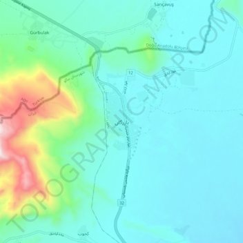
Nome: Mapa topográfico Bazargan, altitude, relevo.
Altitude média: 1507 m
Altitude mínima: 1366 m
Altitude máxima: 2189 m
Until well within the 20th century, Bazargan was not much more than a small village, located at an altitude of 1,550 meters on a delta above the Aqchay river. Bazargan's inhabitants, of Turkic origin, were generally involved in traditional agricultural activities. In 1913, the village was ceded by the Ottoman Empire to Qajar Iran. The village of Bazargan has only developed recently (and that in a limited way), due to the existence of the nearby frontier crossing with Turkey.[4]
Outros mapas topográficos
Clique em um mapa para visualizar sua topografia, sua altitude e seu relevo.
Malham
Iran > West Azerbaijan Province > Maku County
Malham, بخش بازرگان, Maku County, West Azerbaijan Province, Iran
Altitude média: 1277 m