
Mapa topográfico Horst
Mapa interativo
Clique no mapa para exibir a altitude.
Sobre este mapa
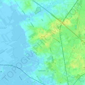
Nome: Mapa topográfico Horst, altitude, relevo.
Altitude média: 5 m
Altitude mínima: -3 m
Altitude máxima: 18 m
Outros mapas topográficos
Clique em um mapa para visualizar sua topografia, sua altitude e seu relevo.
Bokelrehm
Duitsland > Sleeswijk-Holstein > Kreis Steinburg
Bokelrehm, Amt Schenefeld, Kreis Steinburg, Sleeswijk-Holstein, 25596, Duitsland
Altitude média: 26 m
Itzehoe
Duitsland > Sleeswijk-Holstein > Kreis Steinburg
Itzehoe, Kreis Steinburg, Sleeswijk-Holstein, 25524, Duitsland
Altitude média: 19 m