
Mapa topográfico Sohra (Cherrapunji)
Mapa interativo
Clique no mapa para exibir a altitude.
Sobre este mapa
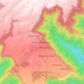
Nome: Mapa topográfico Sohra (Cherrapunji), altitude, relevo.
Altitude média: 1169 m
Altitude mínima: 261 m
Altitude máxima: 1652 m
It has an average elevation of 1,430 metres (4,690 ft) and sits on a plateau in the southern part of the Khasi Hills, facing the plains of Bangladesh. The plateau rises 660 meters above the surrounding valleys.
Outros mapas topográficos
Clique em um mapa para visualizar sua topografia, sua altitude e seu relevo.
Sohsarat
India > Meghalaya > Shella Bholaganj > Nongwar
Sohsarat, Nongwar, Shella Bholaganj, East Khasi Hills District, Meghalaya, India
Altitude média: 372 m
Nongthymmai
India > Meghalaya > Shella Bholaganj
Nongthymmai, Shella Bholaganj, East Khasi Hills District, Meghalaya, 793108, India
Altitude média: 1123 m
Suktia
India > Meghalaya > Shella Bholaganj
Suktia, Shella Bholaganj, East Khasi Hills, Meghalaya, India
Altitude média: 486 m
Nohsngithiang Falls (Seven Sisters)
India > Meghalaya > Shella Bholaganj
Nohsngithiang Falls (Seven Sisters), Shella Bholaganj, East Khasi Hills, Meghalaya, 793108, India
Altitude média: 1043 m
Nohkalikai Falls View Point
India > Meghalaya > Shella Bholaganj
Nohkalikai Falls View Point, Root bridge, Shella Bholaganj, East Khasi Hills, Meghalaya, 793108, India
Altitude média: 1156 m