
Faça uma doação
Prepare-se para a sua próxima aventura:
Como Associado da Amazon, este site recebe uma comissão sobre compras elegíveis sem custo adicional para si.
Mapa topográfico Tacotalpa
Clique no mapa para exibir a altitude.
Faça uma doação
Prepare-se para a sua próxima aventura:
Como Associado da Amazon, este site recebe uma comissão sobre compras elegíveis sem custo adicional para si.
Sobre este mapa
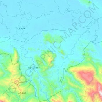
Nome: Mapa topográfico Tacotalpa, altitude, relevo.
Local: Tacotalpa, Tabasco, Mexico (17.34330 -92.91262 17.68922 -92.54570)
Altitude média: 244 m
Altitude mínima: 5 m
Altitude máxima: 2053 m
Faça uma doação
Prepare-se para a sua próxima aventura:
Como Associado da Amazon, este site recebe uma comissão sobre compras elegíveis sem custo adicional para si.
Outros mapas topográficos
Clique em um mapa para visualizar sua topografia, sua altitude e seu relevo.
Villahermosa
Villahermosa is located in the southeast of Mexico between the rivers Grijalva and Carrizal. The average elevation of the city is 10 meters above sea level. The city also has several lagoons, the largest and most important of them being La Laguna de las Ilusiones (Illusions Lagoon).
Altitude média: 9 m
Faça uma doação
Prepare-se para a sua próxima aventura:
Como Associado da Amazon, este site recebe uma comissão sobre compras elegíveis sem custo adicional para si.
Villahermosa
Villahermosa is located in the southeast of Mexico between the rivers Grijalva and Carrizal. The average elevation of the city is 10 meters above sea level. The city also has several lagoons, the largest and most important of them being La Laguna de las Ilusiones (Illusions Lagoon).
Altitude média: 9 m
Faça uma doação
Prepare-se para a sua próxima aventura:
Como Associado da Amazon, este site recebe uma comissão sobre compras elegíveis sem custo adicional para si.
Villahermosa
Villahermosa is located in the southeast of Mexico between the rivers Grijalva and Carrizal. The average elevation of the city is 10 meters above sea level. The city also has several lagoons, the largest and most important of them being La Laguna de las Ilusiones (Illusions Lagoon).
Altitude média: 9 m