
Mapa topográfico Humfeld
Mapa interativo
Clique no mapa para exibir a altitude.
Sobre este mapa
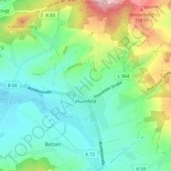
Nome: Mapa topográfico Humfeld, altitude, relevo.
Altitude média: 200 m
Altitude mínima: 132 m
Altitude máxima: 367 m
Outros mapas topográficos
Clique em um mapa para visualizar sua topografia, sua altitude e seu relevo.
Blomenstein
Deutschland > Nordrhein-Westfalen > Kreis Lippe > Dörentrup > Betzen
Blomenstein, Wendlinghausen, Betzen, Dörentrup, Kreis Lippe, Nordrhein-Westfalen, 32694, Deutschland
Altitude média: 192 m
Betzen
Deutschland > Nordrhein-Westfalen > Kreis Lippe > Dörentrup > Betzen
Betzen, Dörentrup, Kreis Lippe, Nordrhein-Westfalen, 32694, Deutschland
Altitude média: 179 m
Hillentrup
Deutschland > Nordrhein-Westfalen > Kreis Lippe > Dörentrup > Hillentrup
Hillentrup, Dörentrup, Kreis Lippe, Nordrhein-Westfalen, Deutschland
Altitude média: 209 m
Spork
Deutschland > Nordrhein-Westfalen > Kreis Lippe > Dörentrup
Spork, Dörentrup, Kreis Lippe, Nordrhein-Westfalen, 32694, Deutschland
Altitude média: 163 m