
Mapa topográfico Prenzlau
Mapa interativo
Clique no mapa para exibir a altitude.
Sobre este mapa
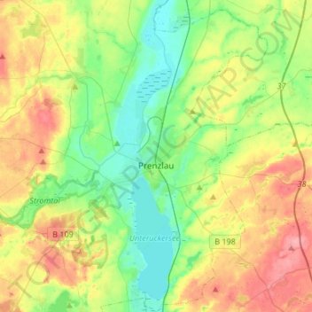
Nome: Mapa topográfico Prenzlau, altitude, relevo.
Local: Prenzlau, Uckermark, Brandenburg, 17291, Deutschland (53.24140 13.75539 53.40144 13.96245)
Altitude média: 48 m
Altitude mínima: 13 m
Altitude máxima: 102 m
Gemeindeteile: Augustenfelde | Basedow | Bündigershof | Dreyershof | Ellingen | Ewaldshof | Magnushof | Mühlhof | Stegemannshof | Steinfurth | Wollenthin – Wohnplätze und Wüstungen: Alexanderhöhe | Ueckershausen
Outros mapas topográficos
Clique em um mapa para visualizar sua topografia, sua altitude e seu relevo.
Buchholz
Deutschland > Brandenburg > Uckermark
Buchholz, Gerswalde, Uckermark, Brandenburg, 17268, Deutschland
Altitude média: 88 m
Pinnow
Deutschland > Brandenburg > Uckermark > Pinnow
Pinnow, Schwedt/Oder, Uckermark, Brandenburg, Deutschland
Altitude média: 49 m
Pinnow
Deutschland > Brandenburg > Uckermark > Gerswalde
Pinnow, Gerswalde, Uckermark, Brandenburg, Deutschland
Altitude média: 60 m