
Mapa topográfico Gemeinde Schönberg im Stubaital
Mapa interativo
Clique no mapa para exibir a altitude.
Sobre este mapa
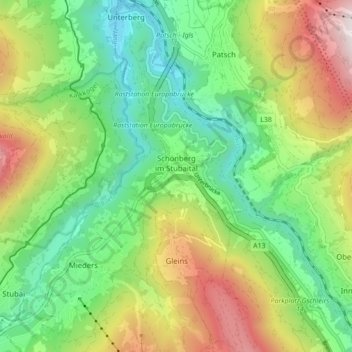
Nome: Mapa topográfico Gemeinde Schönberg im Stubaital, altitude, relevo.
Altitude média: 1107 m
Altitude mínima: 673 m
Altitude máxima: 1839 m
Outros mapas topográficos
Clique em um mapa para visualizar sua topografia, sua altitude e seu relevo.
Gemeinde Seefeld in Tirol
Autriche > Tyrol > Bezirk Innsbruck-Land
Gemeinde Seefeld in Tirol, Bezirk Innsbruck-Land, Tyrol, 6100, Autriche
Altitude média: 1303 m
Puig
Autriche > Tyrol > Bezirk Innsbruck-Land > Marktgemeinde Steinach am Brenner
Puig, Marktgemeinde Steinach am Brenner, Bezirk Innsbruck-Land, Tyrol, 6143, Autriche
Altitude média: 1302 m