
Mapa topográfico Angul
Mapa interativo
Clique no mapa para exibir a altitude.
Angul
Angul (also known as Anugul) is a town and a municipality and the headquarters of Angul district in the state of Odisha, India. Angul has an average elevation of 195 m (640 ft) above sea level. The total geographical area of the district is 6232 km2. From the point of view of area, it stands 11th among the 30 Districts of Odisha.
Sobre este mapa
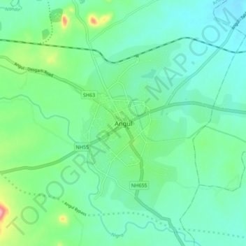
Nome: Mapa topográfico Angul, altitude, relevo.
Local: Angul, Anugul, Angul District, Odisha, 759122, India (20.79824 85.05739 20.87824 85.13739)
Altitude média: 121 m
Altitude mínima: 86 m
Altitude máxima: 237 m