
Mapa topográfico Waukon
Mapa interativo
Clique no mapa para exibir a altitude.
Sobre este mapa
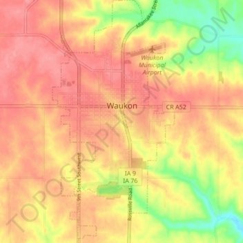
Nome: Mapa topográfico Waukon, altitude, relevo.
Local: Waukon, Allamakee County, Iowa, 52172, United States (43.24146 -91.49526 43.29094 -91.46112)
Altitude média: 373 m
Altitude mínima: 318 m
Altitude máxima: 402 m
Outros mapas topográficos
Clique em um mapa para visualizar sua topografia, sua altitude e seu relevo.
New Albin
United States > Iowa > Allamakee County
New Albin, Allamakee County, Iowa, United States
Altitude média: 209 m
Lansing
United States > Iowa > Allamakee County
Lansing, Allamakee County, Iowa, United States
Altitude média: 228 m
Dorchester
United States > Iowa > Allamakee County
Dorchester, Allamakee County, Iowa, 52140, United States
Altitude média: 300 m
Postville
United States > Iowa > Allamakee County
Postville, Allamakee County, Iowa, United States
Altitude média: 355 m
Elon
United States > Iowa > Allamakee County
Elon, Allamakee County, Iowa, United States
Altitude média: 335 m
Waterville
United States > Iowa > Allamakee County
Waterville, Allamakee County, Iowa, United States
Altitude média: 291 m
Harpers Ferry
United States > Iowa > Allamakee County
Harpers Ferry, Allamakee County, Iowa, United States
Altitude média: 214 m